Courtesy of the Sarasota News Leader
Subscribe to the SNL
Red tide stymies monitoring of offshore sea life required for South Siesta Renourishment Project
Divers did find absence of sponges and dead and stressed corals, likely a result of depleted oxygen levels
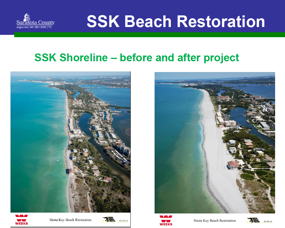
The severity of the red tide bloom that ended early this year significantly hampered the work of a Deerfield Beach consulting firm Sarasota County hired to monitor the impacts of the last South Siesta Renourishment Project, The Sarasota News Leader has learned.
“Conditions at Siesta Key were checked on October 29, 2018 but were not acceptable for underwater work,” the consultant, Coastal Eco-Group, wrote in a report detailing the situation in the nearshore hardbottom area close to the south Siesta shoreline. After late October 2018, further attempts were made to study four areas designated for the monitoring in the second year after the project was completed, the report explains, but each had little success.
Finally, even after the red tide bloom subsided, rough conditions in the Gulf of Mexico dropped visibility levels so low that mapping was not possible, the report says. The survey ultimately was terminated, the report adds.
Nonetheless, limited observations that divers were able to make in November and December 2018 found that “[s]ponges [had] virtually disappeared from the benthic community,” and that that loss “is likely attributed to the prolonged red tide event in 2018.” The report did point out, though, that Hurricane Irma in September 2017 and Hurricane Michael in October 2018 might have dislodged some of the sponges.
Yet, “Harmful algal blooms have been linked to invertebrate die-offs including sponges,” as a result of prolonged periods of low oxygen levels, the report notes.
(The benthic zone is the lowest level of a body of water, including the sediment surface and some subsurface layers, the New World Encyclopedia explains. “Benthic organisms play an important role in food chains, including as food for humans,” the encyclopedia adds, and the “benthic zone provides an area for spawning, foraging, and refuge for various fish species …”)
Dead and stressed and corals that divers were able to observe also most likely were victims of the red tide bloom, the report indicates, as blooms deplete oxygen in the water. One section of the report notes that corals did not appear to have suffered from coverage of sand associated with the renourishment initiative.
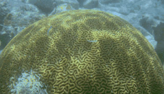
Later, the report references “the losses of large biota (sponges, octocorals and scleractinian corals) observed [during the survey],” adding that the situation appeared “to be related to the effects of the severe red tide and storm dislodgement rather than burial from beach nourishment sand …”
The report focuses on the monitoring attempts for the second year — “Year 2 post-construction,” as it is referred to — following the April 2016 completion of the South Siesta Renourishment initiative. The survey was required by state and federal environmental officials in an effort to determine the effects of the project on sea creatures living offshore of the renourishment area.
The report was submitted to county staff earlier this year and released to the News Leader, at the publication’s request, after the county staff review was completed late last month.
In October 2015, the report points out, pre-construction surveys of three areas were completed, to serve as a baseline for the monitoring.
The Florida Department of Environmental Protection (FDEP) requires monitoring of nearshore hardbottom after renourishment projects because of the importance of hardbottom as an ecological resource.
An April 2018 FDEP document and other materials explain that nearshore hardbottom has the following functions:
- It serves as a shelter and food resource for more than 1,000 recorded species of algae, invertebrates and vertebrates.
- It provides nursery areas.
- It provides spawning sites for more than 100 species of invertebrates and fish.
- It provides recreational opportunities — boating, fishing and diving.
- It dissipates wave energy that otherwise could cause erosion.
FDEP strives to protect nearshore hardbottom resources because of those reasons, the materials point out.
The Coastal Eco-Group report concludes that, based on the observations and results of the Year 2 post-construction survey, “it is unlikely that the current hardbottom monitoring program will be able to detect project-related effects” from the 2016 South Siesta Renourishment Project.
Still, the report says, the “Year 3 post-construction survey will provide valuable data on recovery of benthic communities, particularly sponges, octocorals, and scleractinian corals, following the red tide event and an overall status/condition report of benthic communities adjacent to the beach nourishment project area.”
Monitoring plans
The Coastal Echo-Group report explains that the Biological Monitoring Plan for the South Siesta Renourishment Project required annual surveys of hardbottom habitats updrift and downdrift of the area where approximately 749,238 cubic yards of sand was placed on the beach, between March 9 and April 2016. The sand was dredged from three offshore borrow areas, the report points out.
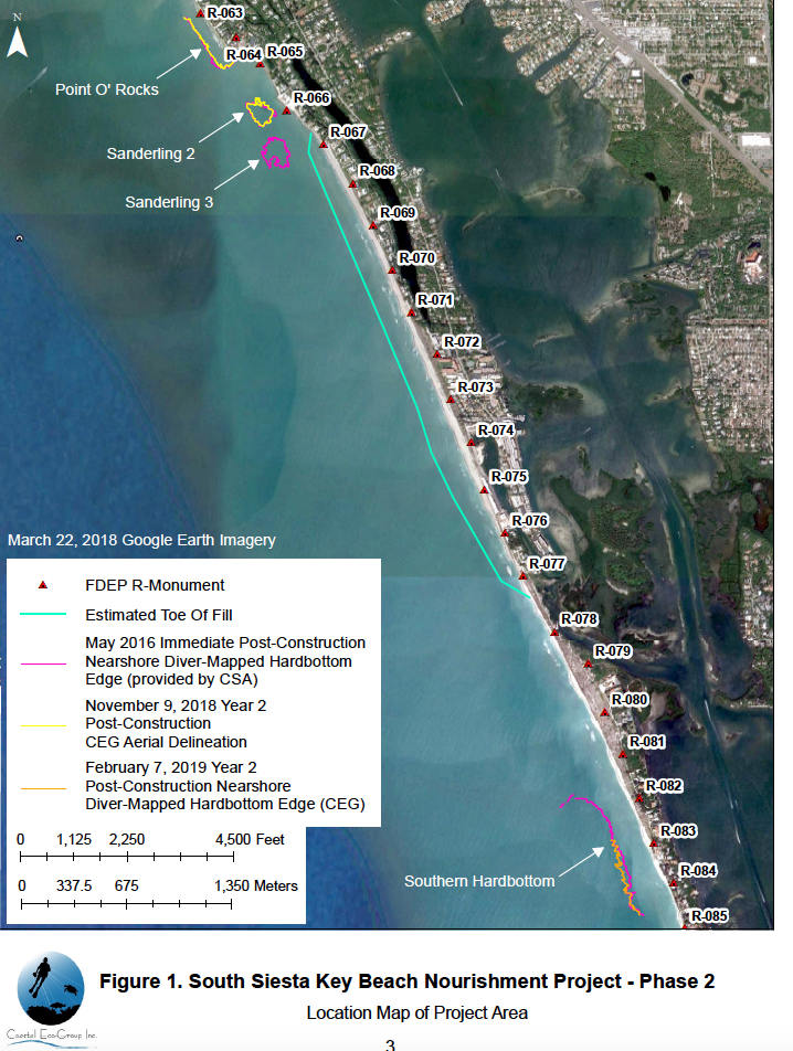
The project area extended from a rock revetment about 3,000 feet south of Point of Rocks to the southernmost house on Siesta Key, according to county staff. The area is approximately 2 miles in length.
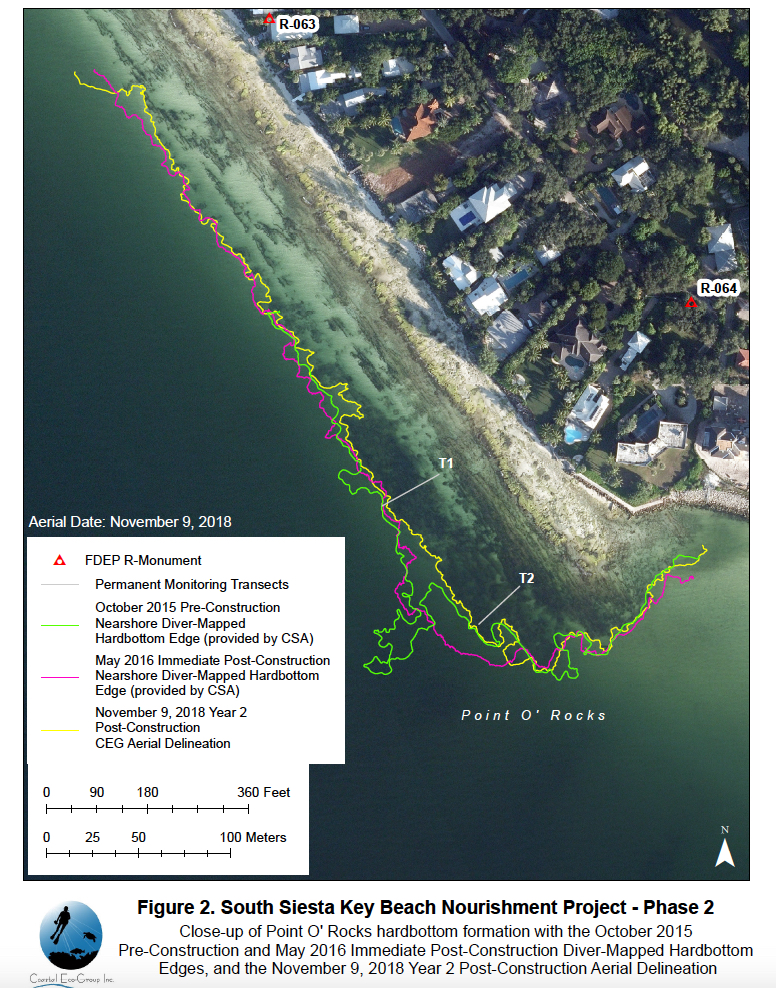
For monitoring purposes, the plan designated three hardbottom areas: Point of Rocks, “Sanderling 2” and “Sanderling 3,” the report notes.
Additionally, the plan encompassed a fourth formation, referred to as Southern Hardbottom, which is located about 0.8 miles south of the southern limit of the renourishment project and approximately 500 feet offshore.
Point of Rocks is located about half-a-mile north of the project boundary, while Sanderling 2 is about 150 feet offshore, between Point of Rocks and Sanderling 3, the report says. Sanderling 3 is located approximately 350 feet offshore at the northern end of the beach fill area.
“The Immediate post-construction survey of all four hardbottom formations was completed … during the summer following project construction in May 2016,” the report notes.
The Biological Monitoring Plan called for three annual surveys, the report continues — during the first, second and third years after construction ended.
In August 2017, when the first annual survey was attempted, the report continues, Tropical Storm Emily’s passage, with heavy rainfall, led to zero visibility in the water. Those conditions persisted until Hurricane Irma passed over Florida in September 2017, the report adds.
The first annual survey requirement was waived by FDEP and the U.S. Army Corps of Engineers, the report says, “due to persistently poor in-water conditions following Hurricane Irma.”
Then, the report continues, “A severe red tide event began in southwest Florida in October 2017. The red tide persisted through the Summer of 2018 such that in-water surveys were not possible.”
After Hurricane Michael passed through the Gulf of Mexico in October 2018, the report points out, “red tide levels started to slowly decline in the waters of Sarasota County.”
The Year 2 post-construction survey effort began in late October 2018 “following two weeks of FWC [Florida Fish and Wildlife Conservation Commission] reports of background to low concentrations of Karenia brevis,” the report notes, referring to the red tide algae.
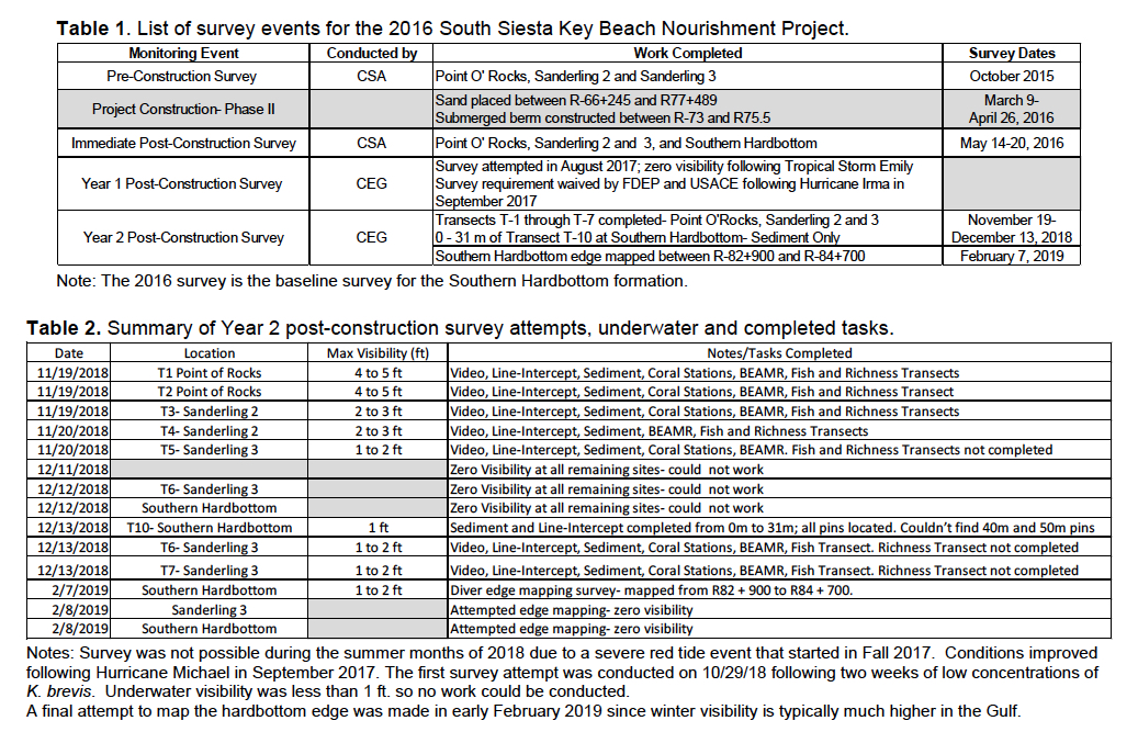
Following problems encountered on the first attempt in October 2018, the report says, a second attempt was made on Nov. 19, 2018. However, visibility at Point of Rocks was only about 4 feet that morning, the report continues, and it decreased in the afternoon to 2 to 3 feet at Sanderling 2. On Nov. 20, 2018, visibility was only 1 to 2 feet at Sanderling 2, the report notes.
Additionally, the report says, “Mild respiratory irritation was reported by … divers during the November 2018 survey attempts; and there were reports of blooms of K. brevis just offshore of Siesta and Longboat Keys during the field survey days.”
The third attempt was made between Dec. 11 and Dec. 14, 2018, the report notes, “during a short period of calm seas. Visibility was absolute zero (blackout)” on Dec. 12 for all the areas scheduled for observation on the Southern Hardbottom and at Sanderling 3, the report adds.
Rough seas again prevented any work on Dec. 14, 2018, the report points out.
“Underwater visibility in the southwest Gulf of Mexico is typically much higher during winter months due to drought conditions,” the report explains. Visibility of 8 to 10 feet “is not uncommon from January through March.”
Therefore, the report continues, the final attempt to map the nearshore hardbottom was planned for early January of this year. “[H]owever, rough conditions following multiple cold fronts pushed the survey attempt to the first week of February. The final survey effort was conducted on February 7 and 8, 2019,” the report says. With visibility “so poor, the nearshore hardbottom edge survey progressed slowly.”
Finally, the post-construction survey was terminated, the report points out.
No comments:
Post a Comment