Showing posts with label clark road. Show all posts

Friday, March 22, 2019

Clark Road widening under consideration

Subscribe to the SNL


Widening of Clark Road to six lanes from I-75 to Ibis Street and realignment of Lorraine Road to be focus of proposed county Comprehensive Plan amendment


Goal is to provide better road network connecting new developments east of I-75
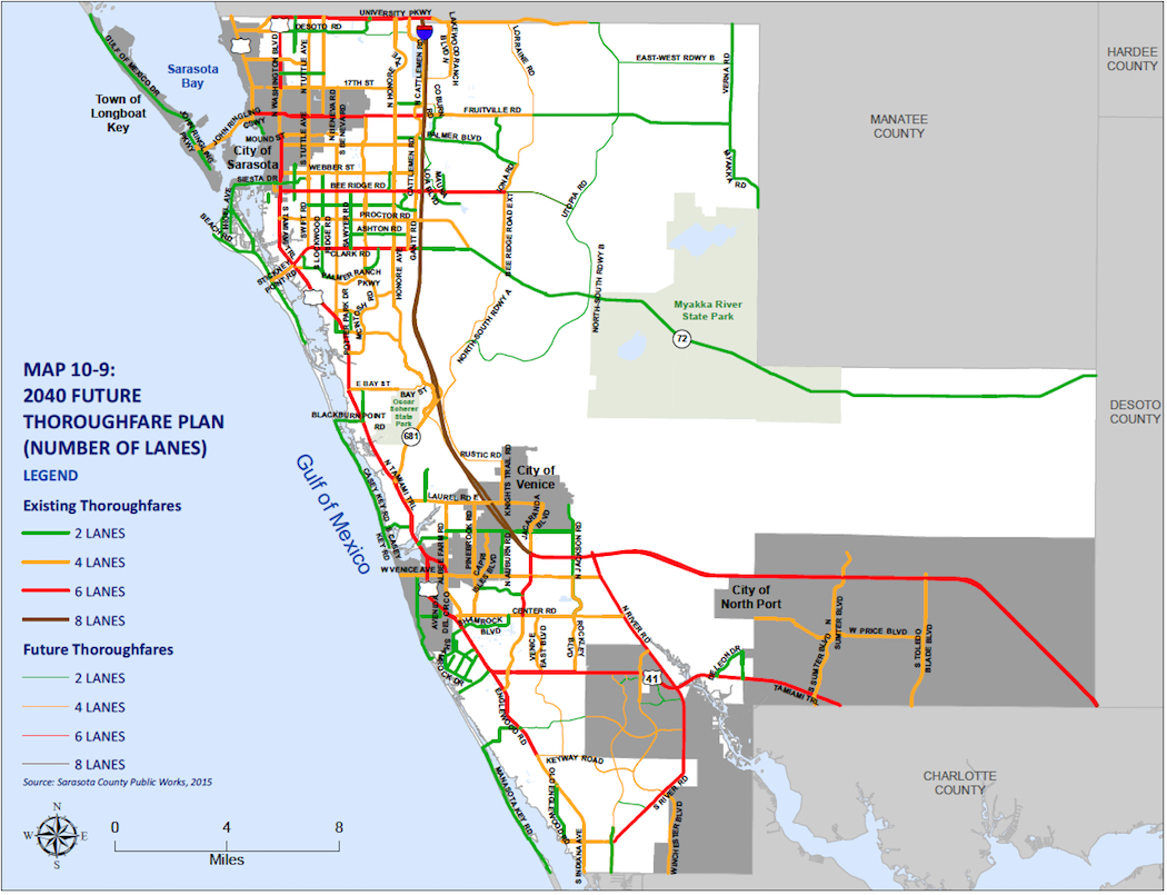
This Future Thoroughfare Map in the county Comprehensive Plan shows ‘North South Roadway A.’ Image courtesy Sarasota County
The Sarasota County Commission has authorized county staff to work on a plan to realign Lorraine Road “to provide a connected network of future roadways east of I-75 to support future development.”
If ultimately approved, part of the process would lead to the reclassification of Clark Road as a six-lane major arterial from Interstate 75 to Ibis Street. Additionally, Clark would become a four-lane major arterial from Ibis Street to Lorraine Road.
An Ibis Road extension was added to the Future Thoroughfare Maps in 2018, a March 12 staff memo noted.
The Florida Department of Transportation (FDOT) defines “arterial” as a divided or undivided roadway that provides a continuous route, serving through traffic, high traffic volumes and long average trip lengths.
The status of Ibis Road was a point of contention during public hearings last year as the County Commission addressed petitions for the Grand Lakes development east of Interstate 75, near Clark Road. Because the Ibis Road extension will not be completed until possibly decades from now — as county staff had testified — residents of the Serenoa Lakes and Serenoa communities stressed to the County Commission that Ibis Street is the only immediate access to their homes and the Grand Lakes site. Those residents would be the closest neighbors to Grand Lakes.
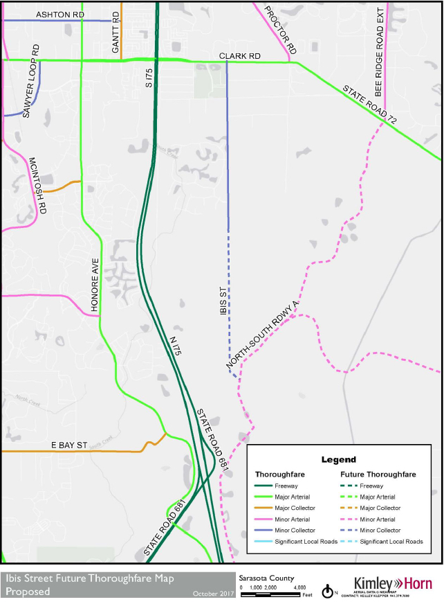
A map shows the location of Ibis Street and the planned extension, east of the site where Grand Lakes is planned. Image courtesy Sarasota County
On a unanimous vote of approval of its March 12 Consent Agenda, the commission formally gave staff the go-ahead to initiate a Comprehensive Plan amendment to the county’s Future Thoroughfare Maps that would not only realign the routing of Lorraine Road — which runs north-south — but also classify Dove Street as a two-lane minor collector.
In December 2016, the memo explained, the commission adopted an updated version of the county’s Comprehensive Plan. In that document, the Future Thoroughfare Plan Maps included Lorraine Road from Clark Road south, “roughly paralleling I-75 …” Lorraine Road then was planned to proceed east along Rustic Road to an intersection with Knights Trail Road.
Lorraine Road was identified on the map as “North South Roadway A.”
Several developments that the County Commission already has approved and others that have been planned “are connected to or utilizing the thoroughfare from Clark Road south to the northern limits of the City of Venice,” where it meets Knights Trail Road, the memo continued. Work on the rerouting of Lorraine Road “presents an opportunity,” the memo said, to analyze possible positive benefits. For example, the memo noted, connectivity could be enhanced, more limited environmental impacts might result and overall infrastructure costs could be reduced.
“Conceptually, staff would examine routing Lorraine Road eastward to Knights Trail Road, north of Knights Trail Park, proximate to the [county landfill],” instead of south of Knights Trail Park along Rustic Road, the memo added.
A graphic presented to the County Commission in March 2018 shows planned Sarasota 2050 villages in the vicinity of the Grand Lakes site. Image courtesy Sarasota County
As for Dove Street: The memo explained that a second facet of the proposed amendment would add that street as a two-lane minor collector from Clark Road to Lorraine Road.
FDOT defines “collector” as a divided or undivided roadway that serves as a link between arterials and local roads “or major traffic generators.” FDOT adds, “Collectors may include minor state roads, major county roads, and major urban and suburban streets.”
With the County Commission’s approval last week of the plans for the amendment, the next step will be the scheduling of a neighborhood workshop, so staff can discuss the plans and then listen to public comments about the proposals.
In response to a Sarasota News Leader question, county Media Relations Officer Ashley Lusby wrote in a March 20 email that staff has not yet set a date for that workshop.
The process also will entail public hearings before both the county Planning Commission and the County Commission.

Subscribe to the SNL

Friday, January 4, 2019

New power lines will not be in Celery Fields area

FPL has made its decision on the route of the new transmission lines that will support growth in East Sarasota County, and it's the choice preferred by the communities near the Celery Fields and the Fresh Start Initiative -- the route along Clark Road:

FPL Power line route along Clark Rd (click image to enlarge)

Celery Fields advocates and residents had expressed concern at an optional route that would have taken the tall power lines along Palmer Blvd and Apex Rd. near the birding, wildlife and recreation area. Here is the communication from FPL manager Rae Dowling:
After an extensive route selection study by the project team, that included feedback from a diverse Community Advisory Panel, an open house meeting, and meetings with neighborhood groups and community leaders, I’m writing to let you know that Florida Power & Light Company (FPL) has selected its preferred route for the proposed Bobwhite-Howard 138 kV transmission line. On behalf of the entire project team, I want to thank you for your participation in our Community Advisory Panel and for the time you invested providing your perspectives for us to consider in our study.  Having the perspective of our customer’s voice in important to us and we truly value your contribution to this important project. The preferred route, which is included in the attachment to this email, follows along almost the entire 13-mile length of existing FPL transmission and distribution lines, a siting criteria consistently endorsed by our customers. Route surveying work will begin on this project this month.  If you have any questions, please contact myself at the numbers below or Daniel Hronec, P.E., Project Manager at (561) 904-3638 or by email at Daniel.Hronec@FPL.com. Thank you. 

Saturday, April 21, 2018

A Road to Nowhere

The Ibis Street Thoroughfare Comprehensive Plan Amendment No. 2017-F comes before the County on Wednesday, April 25 -- it will be found under item 7 on the Board agenda.

Comment by R.N. Collins:

The Sarasota Board of County Commissioners will take the first step towards building a road to nowhere if it approves the Ibis Street Thoroughfare Comprehensive Plan Amendment during an April 25 public hearing.

The county transportation planning department believes that the traffic congestion south of Twin Lakes Park will be so severe in the year 2040 that we need a new thoroughfare to connect Clark Road to a full interchange at State Road 681 and I-75 via another north–south roadway.

But neither the full interchange nor the north-south roadway exist today, and neither is considered financially feasible by the Sarasota-Manatee Metropolitan Planning Organization.

If the interchange is built, FDOT will design and fund it, but FDOT hasn’t even looked into the need for the interchange yet.

And while the north-south roadway is part of a plan to provide an alternate route from Venice to Manatee County, the project is unfunded.  The project recently suffered a setback when the commission rescinded an important funding request for the segment connecting Lorraine Road to Bee Ridge Road Extension.  That segment is a sorely needed connection needed to support development already under construction at the 5000-unit Waterside Village, the 600-unit Artistry community and the 3,500-unit LT Ranch Village.

So it is highly unlikely the proposed thoroughfare will have anything to connect to for many years or decades to come.  Instead of providing connectivity, it will be a road to nowhere.

Actually, that’s not an entirely accurate statement.

The new thoroughfare will go somewhere.  It will dead end at Manatee County-based developer Pat Neal’s 533-acre sod farm where he wants to build 1,100-home subdivision on land zoned for only 258 homes.

Unfortunately for Neal, county regulations prohibit him from building a large development unless the property has direct access to a major road—one that is part of the county thoroughfare plan.

Normally thoroughfare plan additions are considered after the county prepares an in-depth analysis and after the public has multiple opportunities to weigh-in on the proposal.  In fact, the transportation planning department had wanted to consider several changes to our thoroughfare plan during the 2016 comprehensive plan update.  But those changes could not be processed because the county had not held the required public input sessions.

With the county’s holistic thoroughfare evaluation on hold due to a lack of department resources, Neal convinced the county to let him “adopt” Ibis Street and pursue a privately-initiated amendment.

The private process enables Neal to fast track the proposal to designate his access road as a major road.  It bypasses almost all the public engagement that must occur when the county initiates such a change.  And this case, avoiding a lengthy series of feedback sessions and workshops allows the developer to quickly overcome the prohibition on rezoning his property.

I wouldn’t object if putting a line on a map and saying a dead-end country road is a major road was the only effect of Neal’s proposal,

But it does much more.

It allows Neal to divert impact fees away from curing today’s traffic jams and use them instead to improve a dead-end country road that will be used only by his subdivision for years to come.

We believe road improvement priorities should be determined with more, not less, public input.  And we believe impact fees should be spent on real traffic problems we face today, not on ones that are imagined to occur more than 20 years in the future.

Call or email the Sarasota County Commission today and ask them to vote against the Ibis Street Thoroughfare Comprehensive Plan Amendment on April 25.

-- R. N. Collins

Documents relating to the Ibis Street Amendment are here.

Monday, February 26, 2018

FPL to select route by mid-year

In January, FPL shared three possible routes for new power lines to the east of I-75 in Sarasota County.

In response to a follow-up inquiry, a spokesman said the company held a follow up "community advisory meeting" on Feb. 6 and that the goal is "to select a preferred route by mid-year."

The spokesman also shared a fact sheet and suggested that further public comment be sent to Rae Dowling: Rae.Dowling@fpl.com, 941-704-9072.

FPL Fact Sheet


The three routes include: one along Clark Road to the Hi Hat Ranch; one along Bee Ridge Road, and a third along Palmer Blvd near the Celery Fields, then north on Apex to Fruitville Road. More details here.


Wednesday, February 14, 2018

Private Comp Plan Amendment to add IBIS Rd. to Thoroughfare Plan

Privately-Initiated
Comprehensive Plan Amendment No. 2017-F
Adding Ibis Street to Future Thoroughfare Plan

Date:        February 27, 2018
Location: Sarasota County Administration Center, County Commission Chamber, 1660 Ringling Blvd., Sarasota, Florida
Time:       1:30 p.m., or soon thereafter
The Sarasota County Commission will hold a public hearing to consider a resolution transmitting Comprehensive Plan Amendment No. 2017-F, relating to the incorporation of Ibis Street into Sarasota County's Future Thoroughfare Plan Maps and Tables, to the Florida Department of Economic Opportunity for review and comment.

The privately-initiated amendment proposes to add Ibis Street from Clark Road (State Road 72) to Future North-South Roadway "A" to Sarasota County's Future Thoroughfare Plan, as shown on the map below: 

The amendment proposes to revise the Sarasota County Comprehensive Plan including Maps 10-8 and 10-9 of the Year 2040 Future Thoroughfare Plan of the Future Land Use Chapter and Map 10-3a, Map 10-3b and Table 10-5 of the Transportation Chapter.
 
Following the public hearing and subsequent review by the Florida Department of Economic Development, the County Commission will hold another public hearing to consider the adoption of CPA No. 2017-F.  The "tentative" adoption public hearing is scheduled for April 25, 2018.

Copies of the proposed Amendment and supporting documents are available during normal business hours in the Planning and Development Services Department at 1660 Ringling Blvd., Sarasota, Florida.  Supporting documents will be available the Thursday prior to the public hearing at www.scgov.net, Meetings and Agendas (Meetings on Demand) to view or download. 
 
You are invited to comment on the request by attending the public hearing or submitting your written comments to: 
 
Planning and Development Services Department

Please call 941-861-5000; TTY: 7-1-1 or 1-800-955-8771; or email: planner@scgov.net or adacoordinator@scgov.net with your questions.

Tuesday, January 9, 2018

Three options for new FPL Power Line Routes East of I-75

FPL will build a new power line onto its grid by 2020 in East Sarasota. From 28 possible routes it began looking at, it's down to three. One goes right through the Quad parcels at Apex and Palmer Roads.

Information about the proposed 138kV lines was on display Tuesday evening at the Conference Center behind the Girl Scouts building on Catttlemen Rd. near Proctor Rd., Attendance was very low during the hour or more that I was there. It seems FPL contacted folks within 500' of the three proposed routes.

Each of the three possible routes connects the Howard substation at Proctor by I-75 with the Bobwhite station on East Fruitville Rd.

The reason for the new line is to bolster the East Sarasota County grid -- with developers from "the three ranches" -- Lakewood Ranch, Hi Hat Ranch and LT Ranch on East Clark Rd. -- planning tens of thousands more homes, FPL sees good reason to get ready for it now, its representatives noted.

All three routes
The three routes basically run along one of the three major West-East routes east of I-75:


Blue route

  • One marked in blue runs along Clark, then up through an existing easement through the Hi-Hat Ranch property, then west along Fruitville to Bobwhite:


Green route
  • A second in green runs up next to I-75 from Howard, then along Bee Ridge to the Bee Ridge Extension, jogs south and skirts residential communities before connecting to the north-south Hi Hat easement.


  • The third option, in yellow, shows the line going north alongside 75, then running along Palmer Blvd. East to Apex - splitting the Quad parcels - then north on Apex to Coburn to Fruitville where it turns east to Bobwhite.
Close up of line running along Palmer and up Apex Rd.

More photos here.

Asked why of 28 possible routes these were the three t"finalists," FPL reps spoke of costs, feasibility, easements etc.

The few who attended the event were invited to fill out small polling cards prioritizing what was most important to them. It would seem possible for FPL, an electric company, to poll and inform more widely and efficiently through electronic means.

Rae Dowling, area manager for FPL, said she'll be happy to field questions and hear from residents. Her email is Rae.Dowling@FPL.com, and office phone: 941 316-6266.


Tuesday, November 15, 2016

Two visions of East Sarasota County

Last week, the Sarasota County Commission approved LT Ranch -- a 3,450-home project to occupy 1,700 acres a little bit east of I-75 on Clark Road. The vote was 4-1.

Many questions about the exceptions, bent rules, and questionable environmental judgments surround that approval -- more may be forthcoming (Video BCC, Nov. 9th). What deserves mention just now is not the plan, but rather the plea put forward by Commissioner Charles Hines. Hines voted against the project, though he said many of its elements were "great."


Charles Hines
 Photo from SarasotaNewsLeader.com
The reason for his vote was simple: The developer wanted to come in east of I-75 on Clark Rd, which currently has the look and feel of an old country road, and remove a 500-foot buffer requirement in order to locate a 300,000-square-foot shopping center at roadside with a 10-foot buffer.

Such a radical change would destroy the entire look of the road, said Hines. It would also set a precedent for future developers who will seek the same exemptions, exceptions, and bent-out-of-shape-rules for their projects east of the Interstate. There is no need for giant Walgreen signs looming over Clark Road -- the eastern sector of Sarasota county was supposed to be different, Hines said.

Charles Bailey, attorney for the Turner family that is selling the parcel to Taylor Morrison, one of the largest homebuilders in the nation, huddled for a few minutes with his clients, then returned with a counter-offer -- instead of a 10-foot buffer, he said, how about 20 feet?

Hines looked stunned. Red-faced. "I'm offended," he said.


Hines went on to describe a vision of an old country road -- you drive along, heading to Myakka and Arcadia, and as you look from your car, you see open fields, or homes in the distance. It sounded idyllic - but with a shopping center 20 feet from the curb, not very likely. The Turners and Taylor Morrison - and the four other Commissioners - Maio, Caragiulo, Mason and Robinson - didn't seem to get it. Sure, maybe the 2050 Plan had called for a 500-foot buffer, but when has that ever stopped a wonderful project?

In brief, there is an ontological gap between the vision of old Florida, as it still remains, both in memory and in a few places in real life, like Clark Road -- between this Florida and the ambitions of folks like the Turners, Taylor Morrison, and the four Commissioners, who see real estate, widened roads, and commercial buildings in place of vacant pasture.

Between these two opposing imaginings of Sarasota East, you might think there could be some bridge, some mediating point. But attorney Bailey wasn't going to let his clients down. They came back with the offer of a 50'-foot buffer and a tall hedge. Hines opposed, got no second -- the Commission was not going to postpone approval -- those pasture lands were itching to be developed. The plan with its 50-foot buffer was approved, Hines dissenting.

Hines in fact admired much about the LT Ranch proposal. He just didn't want the entire look of the County to resemble Fort Lauderdale.

"This was such an overreach to jam this commercial right up in front, right on that road," said Hines. "I don’t see the benefit."


This approval was but the crack in the seawall. More developers will soon appear before the County, seeking to bend the 2050 Plan to their profit-driven "density needs." Led by a monolithic Republican business cadre, developers and government will make each other happy as cows leaping for joy. They'll just do their leaping in a Publix parking lot.

We appreciate Commissioner Hines' solo effort to get a developer to honor the 2050 plan and a vision of East Sarasota County. Commissioners Robinson and Mason are gone due to term limits. Commissioners Caragiulo and Maio will stand for election in 2018, when Sarasotans can decide their "future development."


LT Ranch on Clark Rd.


Saturday, January 24, 2015

In Plain Sight

Via SRQ


"The flawed assumption operating here is developers must always be permitted to build."

In Plain Sight

The Detail

BY CATHY ANTUNES   |   SRQ DAILY SATURDAY PERSPECTIVES EDITION   |   SATURDAY JAN 24, 2015

They say hindsight is 20/20, but when it comes to 2050, hindsight may be even more illuminating. Changes to the 2050 plan, which governs growth outside the Urban Service Boundary (east of Interstate-75), will impact our wallets, home values and traffic.  Last fall, design standards, open space and fiscal neutrality were being debated.  But the Sarasota 2050 plan was egregiously violated months before when the County Commission approved over 9,344 new homes east of I75 without required Transfer of Development Rights.

TDRs are a linchpin of Sarasota’s 2050 plan. In order to build outside the Urban Service Boundary at higher densities, rural landowners must purchase development rights (either from the County or another rural landowner) and then transfer those development rights to the rural parcel they want to develop. TDR policy is designed to keep the County’s overall density stable. Development density is to be clustered on a particular parcel through TDRs preserving the environment and open space.  The increased density in a focused area provides the ability to build walkable communities—communities which would have a local market, dentist, restaurant, boutiques and the like—and enough of a residential population to provide a customer base. Walkable communities reduce commute times and traffic jams, generate enough tax revenue to pay for their infrastructure. The TDR requirements of 2050 are so central to the plan that during the summer Planning Commission meeting on 2050 changes, Planning Commissioners argued 2050 changes were acceptable because they weren’t increasing overall density.

But, in fact, the Planning Commission and the Board of County Commissioners had increased overall density months before, by failing to enforce TDR policy. In early 2014, both Commissions approved new land-use changes outside the USB along Clark Rd.  Developers were given permission to create 9,344 homes on their land, roughly 5,500 to 6,300 more than the guidelines permit. The Clark Road property owners were permitted to bypass TDR requirements. They contended their land makes it difficult to build densely (that is, walkable communities) and they would have to obtain an unreasonably expensive number of development rights. The development they got approved is the kind of non-walkable, subdivision housing which has been shown to take 42 years to pay off its infrastructure costs (longer than the life of the infrastructure, so existing taxpayers will foot the bill).   It’s also noteworthy that developers get to define what is “unreasonable expense” for themselves. Their claims are not subject to scrutiny. What about “unreasonable expense” for taxpayers?

In a free market, sometimes a project is not economically viable. The flawed assumption operating here is developers must always be permitted to build. The route to economic viability provided these developers by local government includes bypassing TDR expenses, walkable design standards and shifting infrastructure costs to Sarasota taxpayers.   

What about traffic? One local resident commented on social media, “Without this project even starting, accessing Clark Road east of I-75 for those of us who live near Twin Lakes Park is already a nightmare.”  Looks like we’re teeing up another University and I-75 debacle.

In an e-mail to a constituent, former Commissioner Nora Patterson wrote “I honestly believe the one change that knocked the pins out of the [2050] plan was the approval of 9,000 plus units on the north part of the Clark Road property with no exchange of development rights.” She reiterated this point at January’s CONA meeting, saying that it sets a bad precedent. Since the County Commission violated TDR policy in approving the massive Clark Rd density increase, what basis do they have for turning down anyone else?

SRQ Daily columnist Cathy Antunes serves on the boards of the Sarasota County Council of Neighborhood Associations and Sarasota Citizens for Responsible Government. She blogs on local politics at www.thedetail.net