Monday, July 1, 2019

Planning Commission sides with Nokomis residents on Shakett Creek


The owners of the vacant land at the southwest corner of Laurel Road and Albee Farm Road in Nokomis, Florida (851 and 871 Albee Farm Rd, Nokomis, FL 34275) are requesting rezoning from Sarasota County with an unprecedented swap from OUC (Open Use, Conservation) land into RSF-1 (Residential, Single-Family). (Petition 19-04)

WE NEED your help to stop the development of this sensitive land!

THE REZONE PETITION STATES (19-04):

“The Applicants specifically want to rezone approximately 1.015 acres of a fill area in Shakett Creek from OUC (Open Use, Conservation, 1 unit/25 acres) to RSF-1 (Residential, Single-Family, 2.5 units/acre) in order to build one single- family residence on the property. The Applicant also intends to rezone approximately 1.43 acres closer to the intersection of Laurel Road and Albee Farm Road from RSF-1 to OUC in what the Applicant is referring to as a “rezone swap”. The intent is to provide single-family residential zoning on the property where the Applicant would like to build a single-family residence and in exchange rezone another part of the property similar, but slightly larger in size, to OUC for conservation purpose. Much of the property is impacted by Shakett Creek, except for an area in the northeastern part of the property near the intersection of Laurel Road and Albee Farm Road and a fill area in Shakett Creek that is high enough to build. It is the latter fill area in Shakett Creek that the Applicant would like to use to build one single-family residence.”

HISTORY:

The owners bought this land at a highly discounted price from Sarasota County through a tax deed sale (a purchase price of under $25,000 for nearly 15 acres of land that abuts 2 sides of navigable waterways leading to the Gulf of Mexico). Two community workshops were held by the owners to inform neighboring residents of their intention (June 29, 2017 and December 18, 2019). The owners publicly stated that their goal for purchasing this land was to build their family residence on an island that sits at the southwest corner of the property. This island is currently zoned OUC. In order for the owners to build their home there, they are seeking permission from Sarasota County to rezone this portion of their property. They want to swap OUC zoned land with RSF-1 zoned land located elsewhere on the parcel.

CONCERNS SURROUNDING THIS ZONING SWAP:

Response Time by Public Safety Services
Public safety is a concern. The owners of this property have signed a waiver and made it public knowledge that in the event of an emergency, public safety services may be delayed and they are aware of this delay. The delay is due to the fact that the proposed driveway and bridge leading to the building site will not support the weight of heavy emergency service vehicles.

Non-Binding Development Concept Plan
Petition 19-04 is a Non-Binding Development Concept Plan. This means that the owners are not obligated to the plan submitted and it can change at any time. Whereas a Binding Plan means there are no allowable deviations from the approved plans. It is entirely possible that if approved, the owners of this land can build multiple homes on the property.

NOTES FROM THE JUNE 6, 2019 REVIEW BOARD PUBLIC HEARING

Four concerns that arose from the Sarasota review board hearing on June 6, 2019.

Sensitivity of the Swap:
A swap of this nature (OUC to RSF-1) is unpresented and had never occurred within Sarasota County, as stated by a County Employee.

Delay in Response to Public Safety:
A delay in emergency service response time was reaffirmed by Mr. Tom Hicks, a Sarasota County Public Safety representative who spoke at the review hearing. It was also affirmed by Mr. Hicks that this delayed response would pass with the property Meaning if the property was sold, the new owners would have to accept the terms of the Fire Marshall report and the possible delay in emergency response services time.

Non-Binding Development Concept Plan:
When publicly asked by Commissioner Morris “Would you be willing to make a stipulation that if this does go through that you would build a single family house on the property” An agent for the owners stated “I don’t think they are willing to make that stipulation.”

Additional Disturbance to OUC Land:
Notwithstanding the land within the proposed swap; if approved there would be additional disturbance to OUC land granted for personal access and utility easement, potentially up to 700 linear feet along Shakett Creek.

COMMENTS FROM COUNTY PLANNING COMMISSIONERS:

Commissioner Morris: “This is not a good deal for Sarasota County – taking environmentally sensitive land and swapping for something that is zoned RSF-1.” “Not a good trade for Sarasota county.” “The fact that the applicant has come before us and stating one house but absolutely not willing to stipulate that.”

Commissioner Theresa Mast: “… never recalls a swap of sensitive lands to RSF-1” “(She thinks) this applicant knowingly purchased this property in its current state ..” “The community would get the raw end of the deal on this one”

Commissioner Strelec: “…. a real safely issue out there and although people in the fire department can make agreements to that kind of thing it doesn’t change that fact that I think there is a real danger and that is why I don’t support this.”

Commissioner Cooper: “The applicant opened with a statement calling for ‘equal land for equal land’. I think that is a mischaracterization of what is happening here. The only thing equal is their relative size.”

One a final note, Commissioner Theresa Mast thanked the community members who came and spoke in opposition of this petition and carrying themselves in a very professional manner. She stated that commissioners are guided by regulations rather than emotions and have to factor those issues.

REVIEW BOARDS RECOMMENDATION:
The Review Board made a unanimous recommendation to deny Petition 19-04. A final review from the County Commissioners is set for September 10, 2019. If you would like to learn more about this rezoning request and watch the entire review hearing, please do so by following this link:


For more, contract Bill Cantrell at NACA:
Bill Cantrell  |  President
NACA (Nokomis Area Civic Association)
Cellular  |  941-586-8301
billcantrell@verizon.net
www.naca-nokomis.com

Old Miakka residents propose changes to Sarasota 2050 Future Land Use Maps

The following article can be found at SarasotaNewsLeader.com

Citing concerns about changing development policies for eastern Sarasota County, Planning Commission recommends County Commission stop initiative to reduce density near Fruitville/Verna roads intersection

Sunday, June 16, 2019

Sarasota Audubon joins Conservation Foundation to save Rural Heritage at Celery Fields

An update to this post is here.

logo
PLEASE HELP SAVE THE 
CELERY FIELDS
CONSERVATION AREA


The  Conservation Foundation of the Gulf Coast 
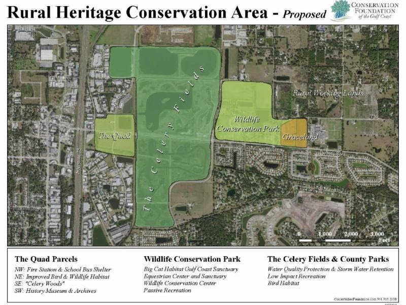
has launched a campaign to help save and maintain rural/farm-type lands east of the Celery Fields. They are negotiating with Big Cat Habitat to put that land under conservation easement (in other words, never to go for development). They have also committed to buying the land east of East Road and north of Palmer which is currently a stables and a big pond--opposite the entrance to a housing development. This piece of land, known as Graceland, is up for sale for $2.55 million.

(All of the above does not address the Quad, although the CFGC is firmly behind the idea of no development. That is another fight that SAS is engaged in).


The Conservation Foundation must raise $650,000 in community donations by June 30, and another $650,000 by September 30 in order to meet their contract deposits, demonstrate community support, and keep this one-time opportunity alive. 

MATCHING DONATIONS
Sarasota Audubon has pledged a 5% match for very dollar donated by its members to saving Graceland (topping out at $5,000 in matching funds)

There are several ways to donate: Sarasota Audubon or 
Conservation Foundation or you can mail a check made out to SAS to 999 Center Rd, Sarasota, FL 34240. We will pass all donations on to the Conservation Foundation.

We deeply appreciate your generosity.  Your children and grandchildren will thank you.

  Yours in conservation,

Jeanne Dubi, Acting President, and the SAS Board of Directors
Christine P. Johnson, President CFGC

Friday, June 14, 2019

Siesta Key Renourishment hampered by Red Tide


Courtesy of the Sarasota News Leader

Subscribe to the SNL

Red tide stymies monitoring of offshore sea life required for South Siesta Renourishment Project


Divers did find absence of sponges and dead and stressed corals, likely a result of depleted oxygen levels

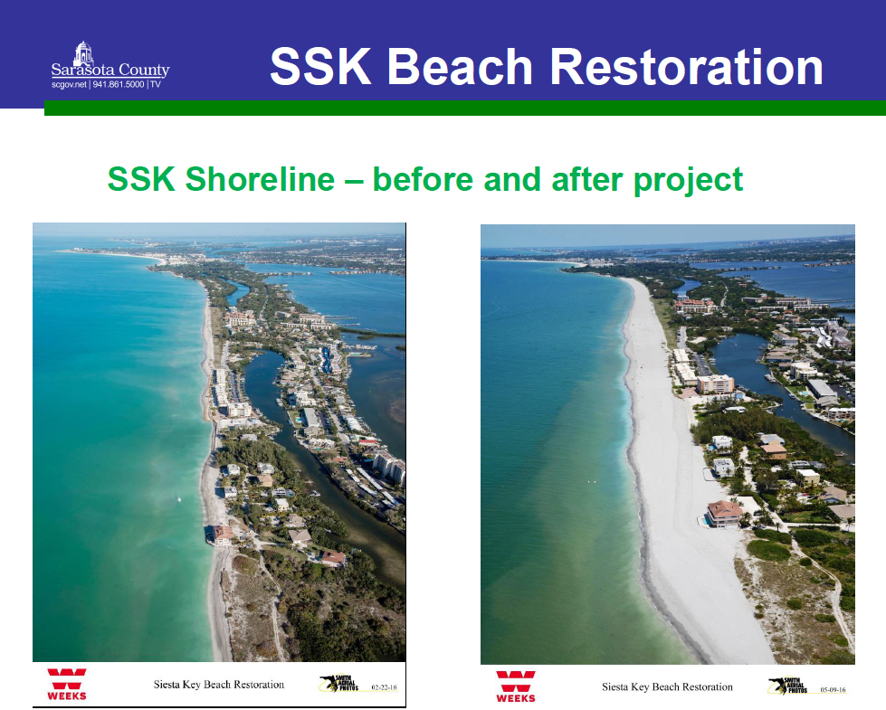
A graphic shows before and after photos of south Siesta Key beach in 2016. Image courtesy Sarasota County

The severity of the red tide bloom that ended early this year significantly hampered the work of a Deerfield Beach consulting firm Sarasota County hired to monitor the impacts of the last South Siesta Renourishment Project, The Sarasota News Leader has learned.
“Conditions at Siesta Key were checked on October 29, 2018 but were not acceptable for underwater work,” the consultant, Coastal Eco-Group, wrote in a report detailing the situation in the nearshore hardbottom area close to the south Siesta shoreline. After late October 2018, further attempts were made to study four areas designated for the monitoring in the second year after the project was completed, the report explains, but each had little success.
Finally, even after the red tide bloom subsided, rough conditions in the Gulf of Mexico dropped visibility levels so low that mapping was not possible, the report says. The survey ultimately was terminated, the report adds.
Nonetheless, limited observations that divers were able to make in November and December 2018 found that “[s]ponges [had] virtually disappeared from the benthic community,” and that that loss “is likely attributed to the prolonged red tide event in 2018.” The report did point out, though, that Hurricane Irma in September 2017 and Hurricane Michael in October 2018 might have dislodged some of the sponges.
Yet, “Harmful algal blooms have been linked to invertebrate die-offs including sponges,” as a result of prolonged periods of low oxygen levels, the report notes.
(The benthic zone is the lowest level of a body of water, including the sediment surface and some subsurface layers, the New World Encyclopedia explains. “Benthic organisms play an important role in food chains, including as food for humans,” the encyclopedia adds, and the “benthic zone provides an area for spawning, foraging, and refuge for various fish species …”)
Dead and stressed and corals that divers were able to observe also most likely were victims of the red tide bloom, the report indicates, as blooms deplete oxygen in the water. One section of the report notes that corals did not appear to have suffered from coverage of sand associated with the renourishment initiative.

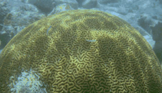
This is an example of scleractinian coral. Image from the University of California at Berkeley

Later, the report references “the losses of large biota (sponges, octocorals and scleractinian corals) observed [during the survey],” adding that the situation appeared “to be related to the effects of the severe red tide and storm dislodgement rather than burial from beach nourishment sand …”
The report focuses on the monitoring attempts for the second year — “Year 2 post-construction,” as it is referred to — following the April 2016 completion of the South Siesta Renourishment initiative. The survey was required by state and federal environmental officials in an effort to determine the effects of the project on sea creatures living offshore of the renourishment area.
The report was submitted to county staff earlier this year and released to the News Leader, at the publication’s request, after the county staff review was completed late last month.
In October 2015, the report points out, pre-construction surveys of three areas were completed, to serve as a baseline for the monitoring.
The Florida Department of Environmental Protection (FDEP) requires monitoring of nearshore hardbottom after renourishment projects because of the importance of hardbottom as an ecological resource.
An April 2018 FDEP document and other materials explain that nearshore hardbottom has the following functions:
  • It serves as a shelter and food resource for more than 1,000 recorded species of algae, invertebrates and vertebrates.
  • It provides nursery areas.
  • It provides spawning sites for more than 100 species of invertebrates and fish.
  • It provides recreational opportunities — boating, fishing and diving.
  • It dissipates wave energy that otherwise could cause erosion.
FDEP strives to protect nearshore hardbottom resources because of those reasons, the materials point out.

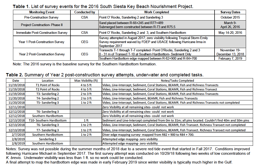
This chart details the survey efforts for the Year 2 post-construction monitoring of the South Siesta Renourishment Project. Image courtesy Sarasota County

The Coastal Eco-Group report concludes that, based on the observations and results of the Year 2 post-construction survey, “it is unlikely that the current hardbottom monitoring program will be able to detect project-related effects” from the 2016 South Siesta Renourishment Project.
Still, the report says, the “Year 3 post-construction survey will provide valuable data on recovery of benthic communities, particularly sponges, octocorals, and scleractinian corals, following the red tide event and an overall status/condition report of benthic communities adjacent to the beach nourishment project area.”
Monitoring plans

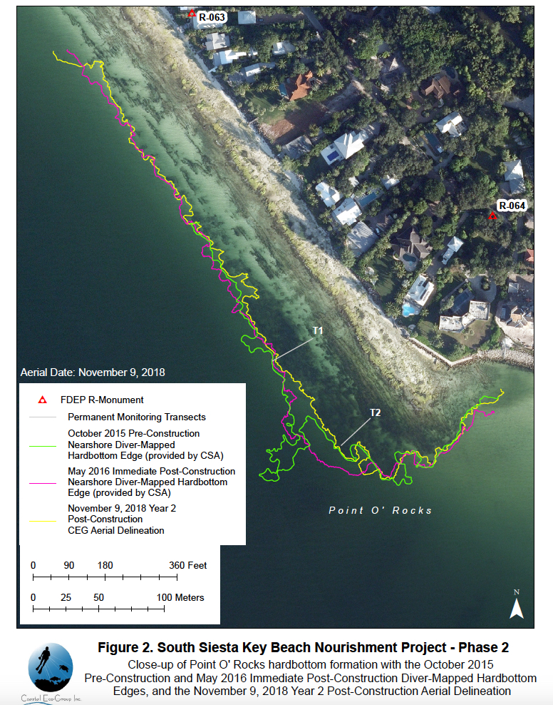
A graphic included in the report shows details about the monitoring efforts regarding the Point of Rocks nearshore hardbottom area. Image courtesy Sarasota County

The Coastal Echo-Group report explains that the Biological Monitoring Plan for the South Siesta Renourishment Project required annual surveys of hardbottom habitats updrift and downdrift of the area where approximately 749,238 cubic yards of sand was placed on the beach, between March 9 and April 2016. The sand was dredged from three offshore borrow areas, the report points out.
The project area extended from a rock revetment about 3,000 feet south of Point of Rocks to the southernmost house on Siesta Key, according to county staff. The area is approximately 2 miles in length.
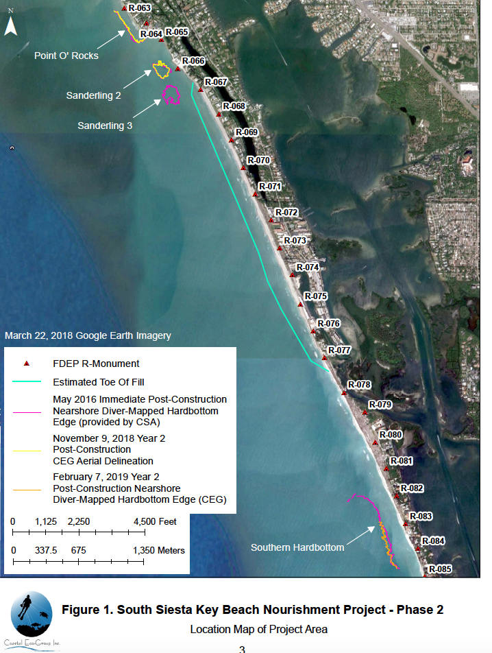
For monitoring purposes, the plan designated three hardbottom areas: Point of Rocks, “Sanderling 2” and “Sanderling 3,” the report notes.
Additionally, the plan encompassed a fourth formation, referred to as Southern Hardbottom, which is located about 0.8 miles south of the southern limit of the renourishment project and approximately 500 feet offshore.
Point of Rocks is located about half-a-mile north of the project boundary, while Sanderling 2 is about 150 feet offshore, between Point of Rocks and Sanderling 3, the report says. Sanderling 3 is located approximately 350 feet offshore at the northern end of the beach fill area.
“The Immediate post-construction survey of all four hardbottom formations was completed … during the summer following project construction in May 2016,” the report notes.

A graphic shows all of the monitoring areas for the project. Image courtesy Sarasota County

The Biological Monitoring Plan called for three annual surveys, the report continues — during the first, second and third years after construction ended.
In August 2017, when the first annual survey was attempted, the report continues, Tropical Storm Emily’s passage, with heavy rainfall, led to zero visibility in the water. Those conditions persisted until Hurricane Irma passed over Florida in September 2017, the report adds.
The first annual survey requirement was waived by FDEP and the U.S. Army Corps of Engineers, the report says, “due to persistently poor in-water conditions following Hurricane Irma.”
Then, the report continues, “A severe red tide event began in southwest Florida in October 2017. The red tide persisted through the Summer of 2018 such that in-water surveys were not possible.”
After Hurricane Michael passed through the Gulf of Mexico in October 2018, the report points out, “red tide levels started to slowly decline in the waters of Sarasota County.”
The Year 2 post-construction survey effort began in late October 2018 “following two weeks of FWC [Florida Fish and Wildlife Conservation Commission] reports of background to low concentrations of Karenia brevis,” the report notes, referring to the red tide algae.
Following problems encountered on the first attempt in October 2018, the report says, a second attempt was made on Nov. 19, 2018. However, visibility at Point of Rocks was only about 4 feet that morning, the report continues, and it decreased in the afternoon to 2 to 3 feet at Sanderling 2. On Nov. 20, 2018, visibility was only 1 to 2 feet at Sanderling 2, the report notes.
Additionally, the report says, “Mild respiratory irritation was reported by … divers during the November 2018 survey attempts; and there were reports of blooms of K. brevis just offshore of Siesta and Longboat Keys during the field survey days.”
The third attempt was made between Dec. 11 and Dec. 14, 2018, the report notes, “during a short period of calm seas. Visibility was absolute zero (blackout)” on Dec. 12 for all the areas scheduled for observation on the Southern Hardbottom and at Sanderling 3, the report adds.
Rough seas again prevented any work on Dec. 14, 2018, the report points out.
“Underwater visibility in the southwest Gulf of Mexico is typically much higher during winter months due to drought conditions,” the report explains. Visibility of 8 to 10 feet “is not uncommon from January through March.”
Therefore, the report continues, the final attempt to map the nearshore hardbottom was planned for early January of this year. “[H]owever, rough conditions following multiple cold fronts pushed the survey attempt to the first week of February. The final survey effort was conducted on February 7 and 8, 2019,” the report says. With visibility “so poor, the nearshore hardbottom edge survey progressed slowly.”
Finally, the post-construction survey was terminated, the report points out.

Courtesy of the Sarasota News Leader

Subscribe to the SNL


Vision of a Rural Heritage Conservation links Quads and Celery Fields and lands to the East


Courtesy of the Sarasota News Leader

Subscribe to the SNL


Community residents working with Conservation Foundation of Gulf Coast to purchase and preserve 23-acre parcel near Celery Fields


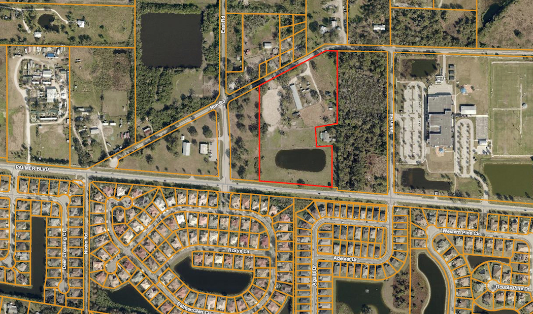
An aerial map shows the location of Graceland Ranch, outlined in red, just west of Tatum Ridge Elementary School. Image from the Sarasota County Property Appraiser’s Office

As debate continues at the Sarasota County Commission dais about the future of county property adjacent to the Celery Fields, the Conservation Foundation of the Gulf Coast is at work on an initiative to create a Rural Heritage Conservation Area in the same vicinity.
A big key to the nonprofit’s plan is the proposed acquisition of a 23.4-acre parcel located off Palmer Boulevard, east of the Celery Fields.
In a June 12 telephone interview with The Sarasota News Leader, Christine Johnson, president of the Conservation Foundation of the Gulf Coast, explained that it had only been a week since the nonprofit had launched its campaign to raise a total of $2,550,000 to buy the privately owned property known as Graceland Ranch.
Residents of the community approached the Foundation, she said, asking, “‘Is there anything you can do?’” They had learned that developers were interested in the Graceland site, Johnson continued, and they wanted to see it remain in a natural state, in keeping with the Celery Fields.
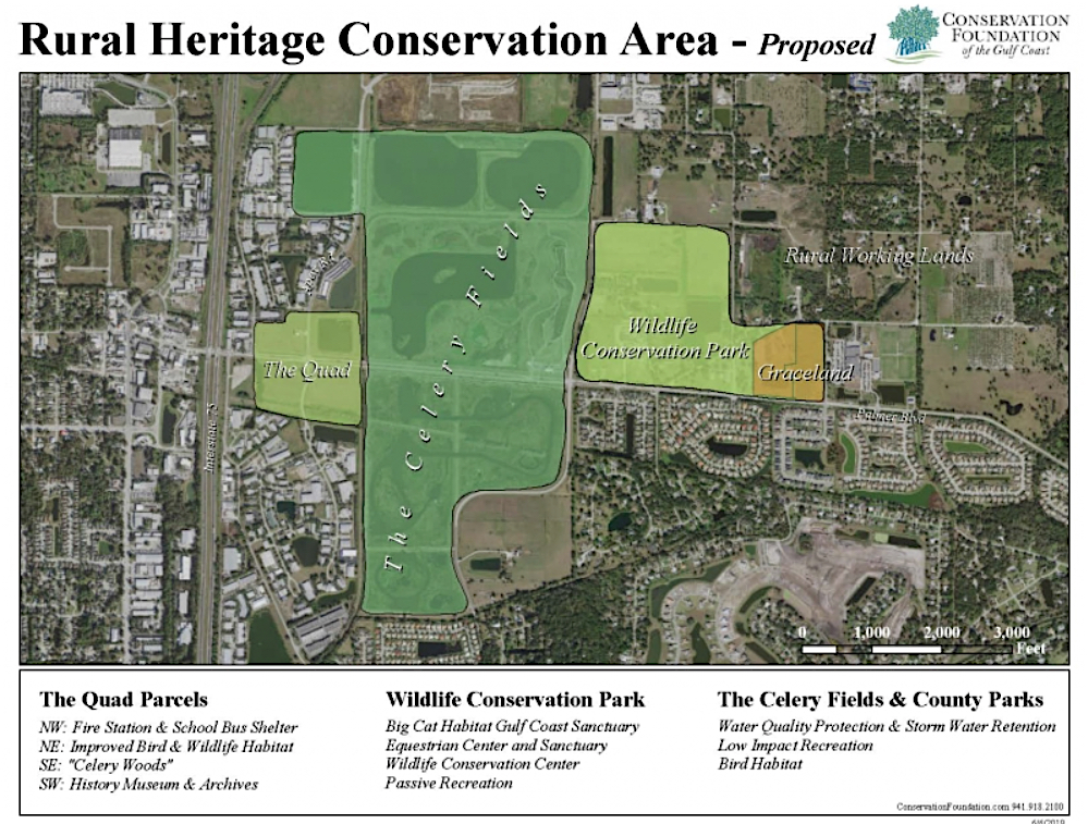
“Graceland is the linchpin to establish a 140-acre wildlife conservation park within a 1,300 acre rural heritage area,” the Foundation says on its website. The property “already is contributing to our community’s quality of life. Graceland provides habitat for wildlife in forested wetlands as well asrecreational opportunities like therapeutic horseback riding and outdoor activities for our youth. This rural heritage area serves as an attractor for visitors and as an amenity for those who live, work and play in Sarasota and Manatee Counties.”

This graphic shows the Rural Heritage Conservation Area the Conservation Foundation of the Gulf Coast envisions with the Graceland Ranch property, Big Cat Habitat, the Celery Fields and the county’s ‘Quads’. Image courtesy Conservation Foundation of the Gulf Coast

The Facebook page for Graceland Ranch notes that the property is located at 7360 Rim Road in Sarasota, just west of Tatum Ridge Elementary School.
Johnson told the News Leader that the Foundation began negotiating with the owner of Graceland Ranch about two months ago. Information the Foundation had received, she said, indicated that two different developers were interested in the land, “nibbling around the edges.” One of those, she continued, seemed pretty serious about constructing approximately 40 homes on the site, even though the land is not zoned for such development.
(The Sarasota County Property Appraiser’s Office says the land is zoned Open Use Rural (OUR). The county’s zoning regulations explain, “The OUR District is intended to retain the open character of the land. This district is further intended for agricultural purposes and uses, and to preserve lands with agricultural development potential. Agriculturally-oriented residential development is encouraged, and all commercial and industrial development is prohibited. … Permitted uses are limited to conservation, agriculture, very low density residential development, recreation, and with certain limitations, other uses that are not contrary to the open character of the district.”)
The owners of Graceland Ranch chose to accept the Conservation Foundation’s offer of an option to purchase the site, Johnson said. Still, she stressed, “It’s really going to be a matter of whether the community wants to save this piece of property.”
The Foundation website makes it clear that the nonprofit needs $650,000 in donations by June 30, with another $650,000 due by Sept. 30 “in order to meet our contract deposits, demonstrate community support, and keep this opportunity, this one-time chance, alive.”
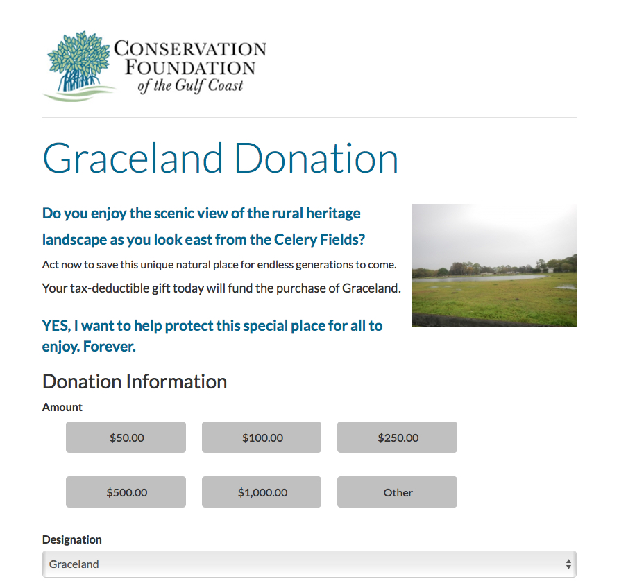
Any person interested in helping with the acquisition can click on a button on the Conservation Foundation website and go directly to a webpage offering a series of steps for making a contribution.

This is part of the webpage that allows an person to make a contribution to the Graceland Ranch acquisition fund. mage courtesy Conservation Foundation of the Gulf Coast

Gifts are tax-deductible, the webpage points out.
‘We save the land’ 
During the June 10 meeting of the Sarasota County Council of Neighborhood Associations (CONA), Debi Osborne, director of land protection for the Conservation Foundation, sought support for the Graceland initiative.
“We save land,” she told the audience members. “We save it forever.”
In the case of Graceland Ranch, she continued, Foundation staff members are working “with willing sellers who are interested in conserving their land …”
If the Foundation is successful in acquiring the property, Osborne continued, “That would then hold the line for the type of more high-density development that’s south of Palmer [Boulevard].”
“We see this as a community effort,” she added.
Sarasota Audubon leaders also are encouraging the public to help save Graceland Ranch from development.

Christine Johnson. mage courtesy Conservation Foundation of the Gulf Coast

An email blast they sent out on June 7 said, “To all Audubon members and those who cherish retaining as much of our environmental lands as we can, the Conservation Foundation of the Gulf Coast is taking the lead in protecting the lands east of the Celery Fields. This foresighted move is in addition to the conservation efforts by Sarasota Audubon, Fresh Start and all residents around the Celery Fields with regard to the [Quads] … If successful, imagine the scope of the protected lands around the Celery Fields! This would ensure a safe environment for the 246 species of birds, as well as all other forms of wildlife in the area. It’s a must for us all to help right now.”
The email encouraged people to donate to the Foundation.
The Fresh Start group mentioned in the Sarasota Audubon email is the same organization that worked with county staff last year — with the support of the County Commission — to propose potential passive uses of the county’s four Quads parcels next to the Celery Fields. Comprising representatives of 50 homeowner associations in the area around the Celery Fields, the Fresh Start Initiative sought to convince the commissioners to focus on long-range planning for the Quads that would be compatible with the Celery Fields, which has become an internationally known bird-watching destination.
Early this year, the County Commission authorized staff to conduct community outreach for a potential amendment to the Critical Area Plan approved years ago for the eastern part of the county that encompasses the Fruitville Initiative. The board members agreed that the Quads could be considered for inclusion in that CAP, for more comprehensive planning purposes.
Nonetheless, on June 4, commission Chair Charles Hines brought up the prospect of the board’s selling the Southwest Quad to any developer who would be willing to create an affordable housing project on the site.
A Fresh Start blog this week noted both the Conservation Foundation efforts and the County Commission discussion last week. The Foundation’s plans, the blog pointed out, would ensure that Graceland Ranch “would receive a conservation easement barring development in perpetuity. The land could be dedicated to equestrian uses benefiting the public: riding, hippotherapy, school visits, education, and more, says [Foundation President] Johnson, who noted that several schools are nearby,” including not only Tatum Ridge, but also Fruitville Elementary, McIntosh Middle and the Farm School.
The blog added, “The Foundation is advocating uses in keeping with the trends and surrounding human communities, integrating a long-range vision of a lasting rural heritage and wildlife conservation for future generations.”

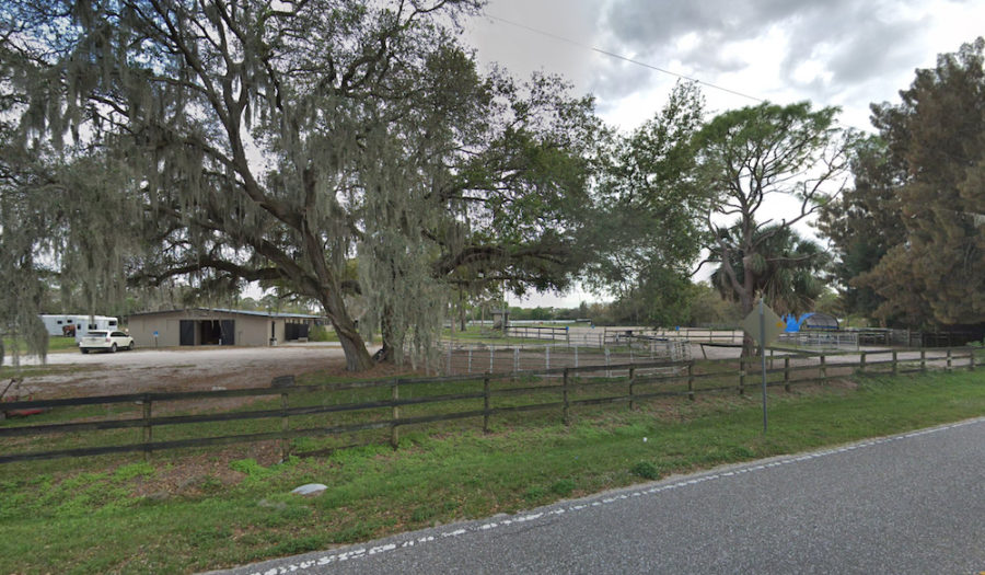
This is a portion of Graceland Ranch. Image from Google Maps

Conversely, the blog says, “[W]hile affordable housing is indeed a goal … Mr. Hines is promoting a quick fix to motivate the private construction of less costly housing, apparently without regard to how such an initiative would impact a host of significant social, environmental, economic and infrastructural concerns in a complex, radically changing area.”
Fresh Start also is encouraging people to contribute to the acquisition of Graceland Ranch.


Subscribe to the SNL


Increase in red tide algae tied to Florida development -- and to Cuban Revolution

Courtesy of the Sarasota News Leader

Subscribe to the SNL


University of Miami scientist links increase in incidence of algal blooms to development in Florida


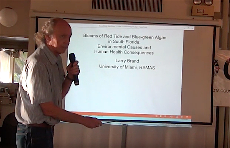
Larry Brand addresses the CONA audience on June 10 in Sarasota. Image courtesy of CONA

Data analysis clearly shows that the more development Florida has seen — and the higher the population has climbed — the more abundant the red tide algae has become in the Gulf of Mexico off the Southwest coast of Florida.
That is just one controversial observation for which Larry Brand, a professor in the Marine Biology and Ecology Department in the University of Miami’s Rosenstiel School of Marine and Atmospheric Science, has been criticized, Brand told the audience during a June 10 presentation for the Sarasota County Council of Neighborhood Associations (CONA).
From 1954 to 1963, Brand explained, data shows that the number of red tide cells in blooms in the Gulf was about 2.5 million per liter. From 1994 to 2002, he continued, that level had increased about 15-fold — to 34.7 million cells per liter. “It’s getting worse.”
For that dramatic an increase to occur, he pointed out, the red tide algae — Karenia brevis— needed 15 times more nutrients.
“I can’t think of any natural nutrient sources that have increased 15-fold over the last 15 years,” he told the audience.
Then where did those nutrients come from? “Basically us,” he said, from agricultural operations and sewage, among other examples.
“A lot of people are not happy about my conclusions,” Brand acknowledged.
Nonetheless, he noted, “I used the raw data.”


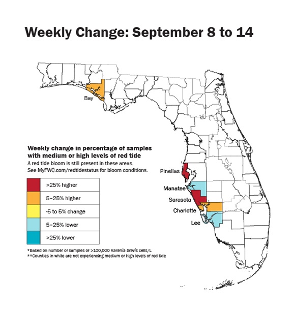
A Florida Fish and Wildlife Conservation Commission shows changes in red tide concentrations between Sept. 8 and Sept. 14, 2018. Image courtesy FWC

Sediment cores taken from Charlotte Harbor from the 1800s on into this century, he said, have demonstrated that the increase in nutrients in that body of water is comparable to the rise in population in Florida.
He also showed the audience several graphs depicting the increase in red tide algae cells in the Gulf during the wet seasons over the past decades, as more runoff flows from inland waterways into that big body of water.
“A lot more nutrients are coming down the Caloosahatchee River,” he added, noting that the U.S. Army Corps of Engineers (USACE) “greatly enlarged” a connection from the river to Lake Okeechobee about 1960.
Initially, Brand pointed out, the lake’s watershed was much smaller. However, over the years, it was enlarged fourfold, to include the sugar cane fields to the south, the Kissimmee River Basin and the Everglades.
“A lot more nutrients are coming down the Caloosahatchee River,” he said, which flows west to the Gulf of Mexico.


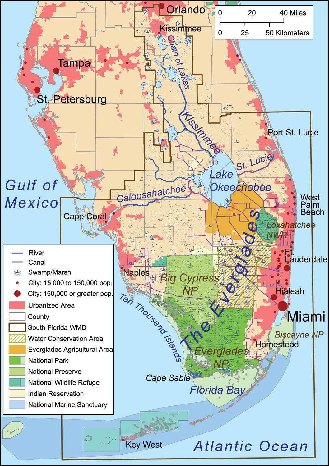
A map shows the Everglades and the Caloosahatchee River. Image by Kmusser via Wikimedia

As the News-Press explains, the releases are designed “to protect thousands of lives south of the lake, as well as large agriculture operations and drinking water sources for millions of Floridians.”
The nutrients also flow to the southwest coast in the Peace River, Brand told the CONA audience.
Whenever he goes on a cruise, he continued, he always sees “a higher amount of algae near the mouth of [the Caloosahatchee].”
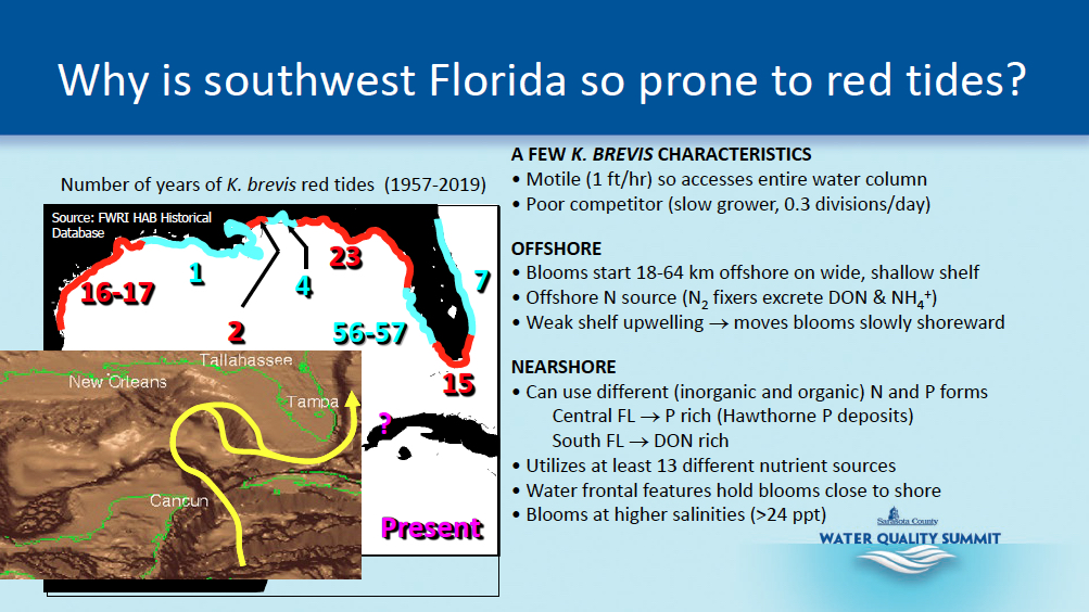
Brand also talked — as red tide researchers with Mote Marine Laboratory have — about the fact that the flow of the Loop Current in the Gulf of Mexico has an effect on red tide blooms. “We never get a red tide when the Loop Current is in the southern position.”


A graphic shows details about the loop current and the continental shelf off the west coast of Florida, both factors in red tide blooms, scientists say. Image courtesy Sarasota County

Brand further concurred with other red tide researchers in explaining that nitrogen is the biggest source of food for Karenia brevis.
The health concerns
During his presentation, Brand also devoted time to the health concerns related to the toxin — called brevetoxin — produced by the red tide algae.
The primary effect, he noted, is respiratory irritation. During the height of blooms, he said, hospital records show that 50% of patient visits were for respiratory distress.
A review of the records also found a 56% rise in cases of bronchitis; a 44% increase in asthma; and a 31% increase in pneumonia, according to a slide he showed the audience.
When the amount of red tide algae in the water reaches the level of 100,000 cells per liter or higher, he added, that is when fish begin dying and people get sick. The discoloration of the water is evident at that level, he noted.
However, periods when the algae is present at levels below 100,000 cells per liter also have increased “quite a bit” in frequency, Brand said.
Thus, even when fish are not dying, he stressed, the algae is present in the Gulf.
About 30 different species of fish absorb the brevetoxin, he continued. Research has shown that those species “all have sub-lethal concentrations of the brevetoxin in them.”


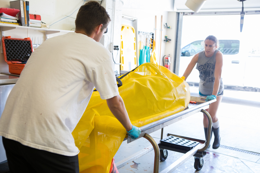
Mote Marine Laboratory staff members bring a deceased dolphin into Mote’s facilities on City Island in August 2018, so a necropsy can be performed to determine if red tide exposure caused the death. Photo by Connor Goulding of Mote Marine

Necropsies performed on dolphins that have died in the Gulf, Brand pointed out, also have provided evidence that the mammals were “packed full of brevetoxin.”
He said he believes those deaths were linked to the amount of fish the dolphins had eaten.
Additionally, Brand told the audience, he suspects that a documented, 40% increase in gastrointestinal problems in humans during red tide blooms is linked to people eating fish that have accumulated the brevetoxin.
The history and the science
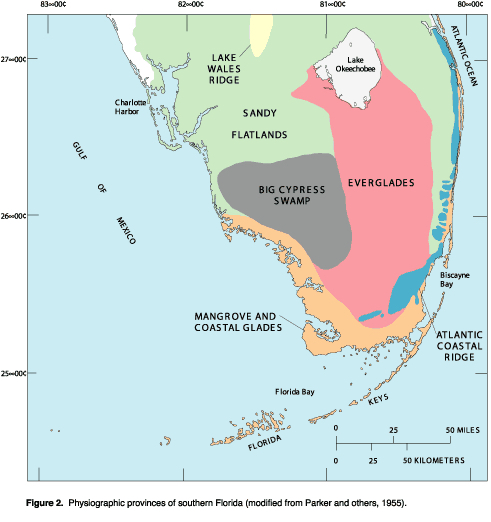
Brand used more graphics as he talked about the geology of Florida, showing how water came to be channeled between two ridges — the Lake Wales Ridge and the Atlantic Coastal Ridge on the eastern side of the state. That water flowed as though it were in a trough, through the basins in that part of the state, as it made its way south to Florida Bay, Brand said.
After the last Ice Age, as the sea level rose and Florida became more humid and experienced more rainfall, he noted, the trough became a wetlands. The Everglades, which is about 5,000 years old, he added, is part of that wetlands.
Over time, he pointed out, all of the organic materials from plants built up into organic peat in that trough, which was “extremely rich in nitrogen.”


A map shows the Lake Wales Ridge, the Atlantic Coastal Ridge and other features of south Florida. Image from the U.S. Geological Survey Archive

Wetlands naturally trap the nitrogen and store it, he said.
When humans drained the wetlands — as they did with the northern third of the Everglades — that organic peat was exposed to the air, he continued; bacteria began attacking it and decomposing it. The nitrogen then was released.
Before the Everglades was drained, Brand said, the organic peat was up to 15 feet deep. “All that nitrogen just ran downstream.”
In 1959, Brand pointed out, as the Cuban Revolution was underway, the United States Government seemed unable to find a way to unseat Fidel Castro as the new leader, so the U.S. began focusing on how it could destroy the Cuban economy. That economy, he emphasized, was based largely on the cultivation of sugar cane.
The U.S. Government began subsidizing the sugar cane industry in South Florida, he said, which led to about a tenfold increase in the size of the crop.
Yet, even though the “huge drainage” of the Everglades occurred in the 1960s, Brand noted, the algal blooms did not start until the 1980s. “What happened? … To keep the sugar cane fields dry, you’ve got to pump out the water, just like The Netherlands.”
The U.S. Army Corps of Engineers (USACE) installed giant pumps and reversed the flow of water into Lake Okeechobee, Brand explained. Instead of water heading south, the water flowed from the lake into the Caloosahatchee and St. Lucie rivers.
However, the filing of lawsuits around 1980 forced the USACE to stop most of the back pumping, he said, leading to a “huge increase of water heading south.”
By the late 1980s, he said, the blue-green algal blooms began in Florida Bay.

Courtesy of the Sarasota News Leader

Subscribe to the SNL